Monday, October 8, 2018

In Your Backyard October 2018 ~ Night of the Living Dead

What fall would be complete without a leaf ride to see the the patchwork quilt of colors on the hillside? Now this is not always a thrill for those grumpy teens that may get drug along for the journey, but if the end result of the trip was a zombie history lesson, that may spark some interest. 
A ride down Perry Highway out of Meadville (also known as route 19) may be just the ticket for some fall and Halloween seasonal fun. So charge up those camera batteries, load the family in the car, pack a little cash for a sweet treat and hit the road. 
Our journey is going to start with a scenic drive down Route 19, through many small towns with unique roadside appeal. Depending on when you go, there is ample opportunity to see different views of the fall colors. 
Continue to follow Route 19 to Zelienople where your first cool stop for the young and old alike. Baldingers Candy Store located at 519 Perry Way, Zelienople will give the adults a trip down memory lane with some nostalgic and hard to find candies from the “good ole days” and excite the kids with the sheer volume of choices. If sweets are not your thing there is also a Mazza wine shop on site which offers tastings. The store is open from 10am to 6pm daily with the exceptions of major holidays and is well worth the stop and you will soon understand where the saying “like a kid in a candy store” stems from. 
Once you reach Zelienople you will want to head east to Evans City, home of the Night of the Living Dead. This 1968 independent horror film by George Romero shaped the modern view of the zombie in ways no one could have ever predicted. Originally the film had a $6000 budget coming from 10 investors with $600 each who formed the production company Image Ten. More money was necessary and the final budget for the film was $114,000 from additional investors. The movie opened in Pittsburgh on October 1st, 1968 (50 years ago) and was received with mixed reviews. The film was criticized for its graphic content and gruesome zombie scenes (Can you even imagine how the some of the modern zombie shows would have been received?) Despite this, the film gained a following and became a cult classic grossing $12 million in the United States and $18 million internationally which was nearly 250 times the budget for the film and spawning a series of films. 

Be sure to stop at the Living Dead Museum and Gift Shop (121 E Main St Evans City) open W,Th,Fri,Sun 12 to 5 and Sunday 10 to 6pm. For a $5 admission fee you can tour the exhibits or go to the gift store for all your zombie gear. The staff is very knowledgable about the movie and a great resource to ask questions about the filming locations. 
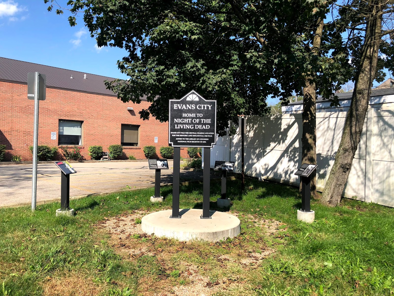
The official marker in town is at 204 South Jackson St near the library and a neat photo, but here is the cool part, you can visit the cemetery used in the film and recreate the iconic images that shaped the pop culture of zombies around the world. A quick google search of “the night of the living dead cemetery images” will give you tons of images to try and match locations to. 
“They’re coming to get you Barbara” will be on your mind as you wander through the Evans City Cemetery located on Franklin Road in Evans City. The Blair grave marker is located on the first road to the left as you enter the cemetery, and the Kramer one (the one Barbara clings to after her zombie encounter) is the tall white one located to the left and back a row. The Cole marker is next to the Blair headstone, and the one that Barbara and her brother go to visit in the first few scenes. The building on site was seen in the movie several times in the background and came into disrepair and was actually restored by fans of the the movie. I had a blast walking around and figuring out the locations from the film. 50 years have passed since the movie was made and trees are larger or removed and new graves have been added, but the locations are very similar to the original once you find them. So go ahead and wander, you PROBABLY won’t get lost. As Seen in Meadville Tribune


Monday, September 10, 2018

In Your Backyard September 2018 ~ Allegheny Geo Trail

Treasure maps have been around since the days of Arthur Teach, the infamous Blackbeard, when they were nothing more than hand drawn parchments with an “X” marking the spot of the hidden booty. Today we have more modern techniques, but the excitement of the search remains. 
Geocaching was started in May of 2000 and now has millions of hidden “Caches” located throughout the world. A cache can be a multitude of things from super small nano caches that are only large enough for a log book, to the standard ammo can or waterproof Rubbermaid container. Inside this cache is typically some small inexpensive items called swag. The items can be anything from small toys to costume jewelry or if you are lucky a trackable. Trackables are logged on the Geocache website and their progress of movement is monitored similar to a “Where’s George” dollar bill. 
I have been a member of the geocommunity since 2005 and when my children were small we had lots of adventures. In fact, since one of the many purposes for the location of a cache is traditionally a cool historic landmark or a wonderful natural feature, many of the locations I have written about in prior articles were found during a geocaching trip. 
Many of you may have heard of Geocaching at some point in the past 18 years. What you may not know is that Crawford County, along with 9 other counties, are part of the Allegheny Geo Trail and are these are considered “AGT Caches”. So what exactly is a Geo Trail you might ask? Well, it is a series of special caches that are linked for a larger purpose, which in this case happens to be special trackable geocoins. The geocoins have no face value and are worth nothing more than the memories that you made obtaining them and of course the bragging rights for earning them. 
As children we often heard “Back in my day...” so I am now chuckling a bit to myself as I write this next part. Back in my early days of geocaching, it required planning the trip on the home computer, printing off the caches that we wanted to try for and using a hand held GPS that my husband used for fishing. It was quite the ordeal and required a bit of effort to have a successful day. Now? There’s an app for that. Quite literally a day of geocaching or a quick trip is located in the palm of your hand. 
In order to join the Allegheny Geo Trail quest, you must first go to www.geocaching.com and sign up for a free account. You can then use your phone to download the official Geocaching App and log in (although there are options for a premium paid account, it is not necessary to join in the fun). You will also need an official Allegheny Geo Trail Passport which can be picked up in Vernon Township at the Crawford County Area Convention and Visitor Bureau (which incidentally is also a Geocache location and your first stamp in your passport) Once you have created your account, have your passport, and logged into the app, you will see all the locations on the map. Just touch one and it will show you the “X” for finding your treasure. (Some locations have clues as well in the descriptions so read them carefully) 
The cache locations that are part of the Allegheny Geo Trail have “AGT” first in the title so you may have to search a bit for them. At each of those locations will be a waterproof container, a unique rubber stamp and a log book. You first need to find the cache, then stamp your passport (replacing the stamp for the next person) and sign the log book and finally, log the cache as found in your app. Once you have found 6 AGT caches in Crawford County, take your passport back to the Visitor Bureau and receive your Crawford County Trackable geocoin. 
But why stop there? Each of the 10 participating counties have their own unique geocoin, and as a bonus if you happen to find all 60 stamps that you need (6 in each of the 10 counties), you can receive a larger Trackable AGT geocoin. Happy Hunting, and as always, remember “Not all those who wander are lost” 

Monday, August 13, 2018

In Your Backyard August 2018 ~ Ashtabula County Covered Bridges

Creek Bridge
 Bridges of Ashtabula County 
While one may not encounter Clint Eastwood or Meryl Streep on their journey to these covered bridges, it is definitely worth the road trip. Known as Ohio’s covered bridge capital, our neighboring county in Ohio has 19 bridges total in two separate loops which you can drive in your car with a downloadable map from their Visitor Bureau (www.visitashtabulacounty.com) 
Boosting both the shortest covered bridge in the United States - the 18 foot long West Liberty Street covered bridge which was built by students from the Ashtabula County Joint Vocational School in Geneva Ohio, and the longest covered bridge in the United States and the fourth longest covered bridge in the world- the 613 foot long Smolen - Gulf covered bridge sits 93 feet above the Ashtabula River and holds Ohio State Rt 25. 
There are two loops for the Covered Bridge Tour the Northern and Eastern Tours. The Eastern Tour is the closest to us and is also the one which contains 13 of the 19 total bridges. I suggest starting on Bridge #6 which is aptly named Middle Bridge since it is the closest to the Meadville area. Once you have found this bridge, just follow the tour map and meander your way through some of the more remote areas in Eastern Ashtabula County. 
Several of these bridges have gorgeous views and are photo worthy, some are historic, some are more modern, and some are located in areas which have other added benefits such as the wonderful swimming hole at #8 Creek Bridge with a generous parking area located at 371 Creek Rd. Bring a picnic lunch and stop at #4 on the tour Graham Bridge. This bridge no longer holds traffic and has a picnic table inside at the one end. Riverview Bridge (#12) is located under #11 the Smolen - Gulf Bridge, it is a pedestrian only bridge that is part of the Indian Trails Park. It offers a nice hike as well as great views of the Ashtabula River and the longest covered bridge above it. Look up while you are there and you will see Smolen - Gulf indeed has a wooden base. As you go up Route 11 in Ohio towards Lake Erie this bridge is visible off to the left past the Jefferson exit. 
Why not pair your trip with a fall leaf ride and a festival? Each October on the second weekend, there is a Covered Bridge Festival which includes everything from classic cars to pancake breakfasts, there is bound to be something for everyone in the family to enjoy. 
So Bridges and Festivals are not your thing? How about a Barn Quilt Tour. What you ask is a barn quilt? Well, I must admit this is something I had to google. A barn quilt is a piece of MDF plywood which has been painted with a quilt design and hung on the outside of a barn. Each quilt design is unique and special to the place or the family who hung it. They are like snowflakes, no two are the same. You can download a tour map at the Visitor Bureau web page for this trip as well and there are currently 100 different Barn Quilts to visit. 
There is also a driving tour through the Ohio Wine Country that hosts 23 different wineries, of course there is a map, once again downloadable at the Visitor Bureau webpage. I am just guessing that a tour through 23 wineries may take more than one trip, remember the DWI laws in Ohio are strict so be sure to designate a driver. 
Don’t have access to the internet? No worries, just call the Visitor Bureau (440) 275-3202 and request their guide book. Which ever tour you chose, remember that part of the joy is in the journey and in the words of JRR Tolkien “Not all those who wander are lost” As Seen in Meadville Tribune
State Road Bridge

Monday, July 9, 2018

In Your Backyard July 2018 ~ Abandoned PA Turnpike

As the dog days of summer are in full swing and the hours of daylight are nearly twice what they were during the winter months, it is the perfect time to push the limits of a day trip. So turn up the tunes, pack many snacks, and switch the AC on for this next Backyard Adventure. 
We are turning the vehicle to the southeastern part of our state to the area around Breezewood, PA. Now, there are many ways to get to this next destination and I would suggest exploring your options a bit. For the history buffs, a journey down Route 30 may be just the ticket with a stop in Ligonier for a tour of Fort Ligonier and the wonderful museum. For others who like nature, take the opportunity to visit one of the many State Parks that dot the Laurel Highlands. Keep your eyes open for some of the many different roadside attractions including quaint antique shops, spectacular views and sweet treats from a mom and pop ice cream stop. It truly is a land which time seems to move a little slower. Now, if you are a person who prefers to just get where you are going, then you can always hop on the PA Turnpike near Cranberry and take the Breezewood exit. 
Where might we be going you ask? Breezewood is just a place to stop and get gas on your way to someplace else, filled with souvenirs and fast food- or is it? One of the best known stops on the current Pennsylvania Turnpike, it is often the Gateway for many in our area to popular destinations such as Washington DC, the Outer Banks, Ocean City and many other coastal destinations. Many of you may have stopped or know someone who has. What you may not have known, is that the current ramp system from the PA Turnpike is not the way it was in the early years. In fact, there is an entire section of the Turnpike just outside of town that was completely abandoned and it even includes two tunnels that you can walk or ride a bike through. Sound interesting? Let me give you a bit of the history so you know what makes this area so unique. Back in the late 1800’s the railroads were the state of the art transportation system and William Vanderbilt wanted to build a railway linking Pittsburgh and Philadelphia. It had an estimated cost of 16 million dollars and 5 years to complete, but in 1885 when the five years were up, only 40% of the line was completed and over 10 million of the budget was spent the project was terminated. This was the first time these tunnels were abandoned and this whole ordeal has gone down in history as Vanderbilt’s Folly. 
Coming out of the Great Depression the Pennsylvania Turnpike idea was born to facilitate automobile transportation across the mountain areas in the state of PA. Using the 7 abandoned tunnels started by Vanderbilt, the first section of the PA Turnpike, dubbed “The Road of the Future”, was opened on October 1st, 1940. This was the first limited access toll road in the United States and is the predecessor for all the other Turnpikes and Toll Roads we have today. When the road originally opened, there were no posted speed limits, except for the tunnels which was 35mph and it was similar to the German Autobahn. Speeds in excess of 90 mph were traveled and so in 1941 a speed limit was posted of 70mph. Let’s think about that for just a moment, 90 miles per hour in your grandparents/parents 1940’s Chevy- tell me that was not a wild ride! Over the course of its history the Turnpike has had multiple decreases and increases in its speed limit, and in recent years has come full circle back to its original posted speed limit of 70mph. 
The road, also named “the Tunnel Highway” was extremely popular and immediately there were bottleneck issues at each of the 7 portals where the four lanes of traffic had to condense to two lanes in order to enter the tunnel. The idea came about to “twin” the tunnels to add the additional lanes and keep the traffic flow moving. It was determined that the Rays Hill, Sideling Hill and Laurel Hill Tunnels were not cost effective to twin and in 1968 two sections and three tunnels were abandoned for the second time. The Laurel Hill Tunnel is in a section of Turnpike that was bypassed located in Westmoreland County near the town of Donegal and is reportedly under private lease to the Chip Ganassi Racing Team for aerodynamic testing on race cars. It is all quite hush hush and getting actual current information on the tunnel is difficult. One thing is certain, it is private property and not accessible to the public. 
The Rays Hill Tunnel, which was the shortest tunnel in the original Turnpike and the Sideling Hill Tunnel, which was the longest as well as the 8.5 miles of roadway that was bypassed near Breezewood are on property that is now part of the Pike to Bike Trail. The Cove Valley Service Plaza was also abandoned as part of the bypass. 
There are two trailheads to this bike/hike path but the easiest trail access without climbing a hill with loose gravel is located off Pump Station Rd. From Breezewood, you will travel about 7.5 miles on US 30 East and make a left turn onto Pump Station Rd. Travel approximately 3 miles until you see a parking lot and the beginning of the trail. 
If you bring your bikes, which I highly suggest because it is a fantastic way to travel this trail, you will want to be aware of a few things. First, there are not facilities located nearby, so make sure you have any water or snacks with you and use the restrooms in Breezewood prior to heading out of town. Second, the trail is unimproved, it is a section of roadway that was abandoned in the late 60’s and nature is doing its best to reclaim the area. The roadway is broken and cracked so bikes with wider tires fair much better than a 10 speed racing bike. Third thing to keep in mind is the tunnels are VERY dark, once inside you will not be able to see the other end so you will need a light in order to see where you are going. They are also about 55° so keep that in mind if you are a cold blooded person. 
As you begin your journey on this almost post apocalyptic looking stretch of roadway you may recognize the scenery if you watched the 2009 movie The Road which was filmed in part here as well as our very own Conneaut Lake Park. On your route from the parking lot in about .3 miles you will see a large parking lot to your right with an island of trees. This is the Cove Valley Travel Plaza and the trees are growing up in the former foundation of the Howard Johnson’s Service Center. These centers were located along the Turnpike prior to the onset of the fast food restaurants we have now. 
Traveling about 1 mile father and you are at the entrance to the first tunnel, Sideline Hill Tunnel, and the longest tunnel on the former Turnpike. This tunnel is 1.28 miles long and the grade is curved up in the center for drainage so you definitely can not see the other end. It does not take long before you are surrounded by complete darkness. 
Fun Fact, supposedly the legendary creature the Windego lives in these tunnels. For those who do not know, the Windego is an Algonquin legend of a creature who has an insatiable taste for human flesh. This fact was not known to me while I was in the center of the tunnel by myself with the echos of each water drop or rock my tire sent flying sounding like something was behind me. Pretty sure nothing like a cannibal big foot creature would inspire one to pedal faster. 
Next up is the Rays Hill Tunnel even though this tunnel is about half the length of the previous tunnel you will still need a light as you plunge into the cool darkness. Once you have emerged on the other side of Rays Hill you are just a little over a mile from completing the entire 8.5 miles of the Abandoned PA Turnpike. You will see places that have reflectors installed into the pavement or the line rumble strips that are found on many of today’s modern highways, this is where they were tested prior to installation. 
Hopefully you enjoyed your journey through an important piece of American history. As always and until next time, in the words of the great JRR Tolkien “Not all those who wander are lost”

Monday, June 11, 2018

In Your Backyard June 2018 ~ Vampire Crypt, Witches Circle, Spider Car

 Vampires, Witches and Spiders, yes, it does sound more like a Halloween outing rather than a summer escape. But stick with me and you will find out just exactly why I decided to not wait for October to tell you about this backyard adventure. 

Many of us have cute figures made out of “found” objects adorning our yards. A few kitchen utensils and a hubcap and you have yourself a very unique lawn ornament. But what if the hubcap was still attached to the wheel? Or better yet- the entire car? That is just exactly what Dick Schaefer started to do back in 1988. Located at 3705 Hershey Rd Erie, Pa 16506 the Schaefer Auto Art is a must see on everyone’s list. A bumble bee made from half a cement truck, a rocket ship and of course a spider which is made from an intact VW Bug. This place has been on Ripley’s Believe it or Not! Unlock the Weird and featured on Roadside America. Hours are from sunrise to sundown, parking is a turnout along the roadway (they ask that you not pull into the driveway) and the cost is free. There are many places online that you can log your visit and post your photos if you so choose to share them and they can be accessed at www.schaeferautoart.com. 
Now, we have covered the spiders, so on to the Erie Cemetery located 2116 Chestnut St Erie, Pa 16502 for some urban legends and history. The Cemetery opened in 1851 and is 75 acres of some of the most ornate headstones I have ever seen. General Strong Vincent is buried here along with many of Erie’s early industrialists. General Vincent was the Union officer during the Civil War that led the 83rd Pennsylvania Infantry during the Battle at Gettysburg and was mortally wounded while fighting at Little Round Top. The cemetery is open during daylight hours while the gate is open, which is one of the reasons to have this be a summer trip when the days are much longer. Since it is a place of reverence they ask that you do not go over 10 miles an hour and turn off your car’s stereo. There is a downloadable walking tour map at www.eriecemeteryassoc.com filled with famous Erie natives. 


There are however two places that are most definitely not listed among the highlights of the tour. First is the Witches Circle which is located in one of the oldest parts of the cemetery along Chestnut St. To locate this, you must first go through the main gate and turn left, continue to drive until the headstones start getting much, much older. To your left along the fence side of the roadway you will come across a circle of tombstones near a tree. Two of the stones are blackened and if you go to the base of the tree you will also see a stone that the tree almost totally engulfs. Just the very tip of the stone remains. Legend has it that there was a Coven in Erie practicing in the late 1800’s, now keep in mind this is where all the legends start to differ. It is told that the two stones that are blackened are the leaders of the Coven and the evening of the burial of the last leader there was a horrific thunder and lightning storm and the next morning the two stones were charred. Another states it was the devil himself that burned the stones taking their souls, and the most likely story is it is just acid rain that has discolored the headstone. But then, why only the two? 
The other urban legend is a bit more precise and very well known. It starts with a very plain mausoleum perched on the hilltop. To get there you must continue along the road past the Witches Circle until you come to a circle drive that goes over the crest of the hill towards 26th street. The road is one way to your right, so be sure to go the proper direction. You will drive the entire loop along the top and then when you start to descend you will see an unmarked tomb to your left. This dark colored monument is marked only with a floral design that oddly can appear to be in the shape of a “V” the name above the door has been purposely chiseled off more than a century ago. This eerie place in the Erie Cemetery is widely known as the Vampire Crypt. The mystery surrounding this is based on a legend that an Erie man fell ill after a trip to Romania and later died of consumption. it was shortly after his burial that the tales began. Supposedly the suburbs surrounding the cemetery started to have strange deaths in which the bodies were drained of blood, and there were two puncture holes in the necks. The story continues that a groundskeeper of the cemetery figured out what was happening and he 
chained the door, burned the crypt (giving it it’s blackened appearance) and chiseled the name off from above the doorway. Many tales follow of different untimely deaths from those who have since after entered this tomb and you are only one Google search away from deciding for yourself if any of the stories are credible. As I stated earlier, these are all Urban Legends so that means there is very little proof of any of the claims, just circumstantial evidence and lots of imagination. But it sure does make for a great campfire story. 
So there you have it, Vampires, Witches and Spiders, and certainly a bit less creepy to visit on a summer afternoon then at Halloween. That does not mean however you can’t make a return trip..... if you dare! Remember as you stroll the 75 acres of the Cemetery, “Not all those who wander are lost”-JRR Tolkien


As Seen in Meadville Tribune

Monday, May 14, 2018

In Your Backyard May 2018 ~ Apollo Spacecraft and Bellmar Bridge


The temperatures are finally rising and the sun is making more than one appearance each week so that means summer is within sight. That also means that school will be letting out for vacation and there will be quite a bit of quality family time available. Which generally means that after about the first week of no school the litany of “I’m bored... there’s nothing to do” will start. 
Few things brighten a child’s face on a 80 degree day quite as much as “Do you want to go get an ice cream cone?” If that ice cream cone comes with a cool history lesson then you have also managed to do your duties as a parental unit as well. (A total win-win situation.) So pile the family in the car and head over to Franklin Pa Dairy Queen located at 1578 Pittsburgh Rd Franklin, Pa 16323 which is also known as Route 8 South. Why drive 40 mins for an ice cream? For the chance to see up close and personal one of the 4 remaining Apollo Space Mission Training Capsules and to sit in an airplane booth while enjoying your frosty treat. These training capsules were used back in the early 70’s to help train Navy recovery personnel for when the manned capsules came back from space. Most of these training capsules were sold for scrap metal when they were done being used and now only 4 survive. One is in storage at the Smithsonian Institute, one is on display in Cape Canaveral, Fl and the two remaining are privately owned, including this one on display in Franklin. 
On your drive to the Dairy Queen if you came from Franklin, then you went past Pone Lane. (it is the road to your left that has the stop light). If you want to plan to make a great day trip out of your ice cream adventure then be sure to check out the Sandy Creek Trail. Take Pone Lane all the way to where it comes to a “T” and turn right onto Belmar Dr. You will be on Belmar Dr for a little over 3.5 miles when you will see the parking for the trailhead on your right. Word of caution, the road is extremely steep and curvy near the end of the trip. In fact it is so steep that I smelled burnt brakes on the mini van the very first time I made the trip so proceed with care the last half mile or so. Don’t fret though, the prize at the bottom is well worth the white knuckle drive to get there. The Belmar Bridge is a part of the Sandy Creek Trail and is an old railroad bridge that has been updated to a bike/hike path. The trail itself is paved and the total length is 12 miles and has 7 bridges (including the Belmar Bridge) and one tunnel. Whether you hike it or bike it, it is a great excuse to get the large ice cream since you will be burning so many calories. 
Once you have had your ice cream and trail fix it is time to head back to Franklin for one last glimpse of history. There is a fantastic Indian artifacts display located within the Venango County Courthouse. If you are leaving the trailhead for Sandy Creek you can just go straight back up Belmar Dr past the Pone Lane turn, at the intersection of Congress Hill Rd (which comes from the left) the road turns into Bully Hill Rd. No, I really did not make that up Congress Hill does turn into Bully Hill. Once you have gone down the hill it will turn into 3rd Street and then goes past the former Joy Manufacturing. Back to the ice cream topic, I was devastated to learn as a child that this particular Joy plant was NOT in fact the one that makes ice cream cones. From 3rd street you will come to Liberty St. here you will turn left and be back in downtown Franklin and the County Courthouse will be on your right. The entrance to the courthouse is located in the rear of the building and be prepared to empty all your pockets to go through the metal detector. The artifacts including arrowheads and pottery are on display in the second floor hallway which is open to the public. 
Hopefully this summer inspired excursion will have your family of cosmonauts smiling and give a fun history lesson for their “what I did this summer” essay. As always please remember in the words of the great JRR Tolkien “Not all those who wander are lost”


As Seen in Meadville Tribune

Monday, April 9, 2018

In Your Backyard April 2018 ~ Freedom Falls and Rockland Iron Furnance

With the snow from this past winter melting and entering the creeks as fast as a toddler can remove their socks, it is a great time to head for a local waterfall. There is one particular waterfall which is not terribly difficult to find, however it is off the beaten path and not extremely well know. Freedom Falls is located at 227 Rockland Station Rd Kennerdell, Pa 16374 for those who are using a GPS system. For those who are not, take Route 322 through Franklin to Cranberry and at the light (and Sheetz) turn right onto the Cranberry/Rockland Rd. This is where it gets a little tricky- you will pass a sign for the Kennerdell Lookout located on Kennerdell Rd and this is well worth the quick side trip if you have never seen it (however it is far more impressive in the fall once the leaves have changed color). After the Kennerdell Rd the Cranberry/Rockland Rd changes names and becomes the Pittsville Rd. Just continue straight and you will see a sign that simply states “Pavement Ends”. Yes, I did tell you that it was off the beaten path. You will see a road to the right, this is Rockland Station Rd. Continue approximately 1 mile and you will see a turn off on the left hand side of the road. Park and as soon as you open the door you will hear the sounds of the falls. Be careful as you make your way there as the slope is steep, I have found it much easier to go from the lower side and make my way upstream. 
Also located from the lower side of the falls is the remains of the Rockland Iron Furnace built in 1832 and was used for smelting what was known as pig iron. It took a crew of 40 men to operate when it was in production. The 25 foot tall structure was built by Andrew McCaslin. One day he and his wife, along with a load of the pig iron were on a barge headed for Pittsburgh, when somewhere downstream the barge capsized drowning both of them. The furnace then changed ownership several times and was subsequently shut down in 1857. 
Once you have had your fun exploring the furnace sight and checking out the falls, I would continue just a bit father down the Rockland Station Rd to the trailhead for the Kennerdell Tunnel. This tunnel is part of the Allegheny River Bike path and is 3,350 feet long. You do not necessarily need a flashlight to enter the tunnel, but it does get a bit dark near the center and can be a bit unnerving to walk in the near pitch black. Do not worry though because the light at the proverbial end of the tunnel in this case is not a train. The tunnel was built in the early 1900’s for Conrail as a freight line and has long since been a recreational use tunnel for bikes and pedestrians. Once you have entered the tunnel you will notice a pretty drastic change in the temperature, so if it is a nice spring day you may want to grab a jacket as well as a flashlight. 
While the trip in the spring affords a great view of the Freedom Falls in all its glory, a trip back in the fall is well worth the effort for the fall foliage, so you may want to plan two trips and get the most of this small little corner of the world that is not very well known. For those who are really adventurous and want an all day biking trip, you can pick up the Allegheny River Trail just outside of Franklin and cycle the approximately 15 miles to the tunnel, from there you can take the short hike up the road to see the falls and the furnace. 
Whichever way you chose to visit, I hope you enjoy yourself and remember in the words of the great JRR Tolkien “Not all those who wander are lost” As Seen in Meadville Tribune


In Your Backyard October 2020- Benezette Elk

October is my favorite month of the year, when the leaves begin to change, pumpkin spice seems to become the favorite condiment and the weat...